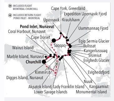
Churchill to Pond Inlet - Canada & Greenland Luxury Expedition Cruise itinerary:
show reverse itinerary
Days 2 - 3 Churchill, Manitoba
Archaeological evidence around Churchill indicates the former presence of Pre-Dorset, Dorset and Inuit groups, with the earliest date going back some 4,000 years. On the western shore of Hudson Bay and at the mouth of the Churchill River, Churchill became an important base for the Hudson’s Bay Company and the fur trade. Two forts were built in the early 18th century, both on the Canadian National Historic Site list. A Parks Canada Visitor Center in the VIA Rail Station shows exhibits of the human and natural history. Today Churchill is a town of about 1,000 inhabitants which can only be reached by rail on land, by air, and in the case of ships only between July and November. The deep-sea port facilitates primarily the transport of Western Canadian grains. Once the ice breaks up in the Churchill River Basin, beluga whales come to feed and rest by the hundreds. With sub-arctic tundra and boreal forests, the area between Churchill and Nelson River to the south is well-known as polar bear country. Churchill even has a Polar Bear Holding Facility, better known as the Polar Bear Jail.
Day 4 Walrus Island & Marble Island, Nunavut
Walrus Island is one of three uninhabited Canadian Arctic islands in the Kivalliq Region of Nunavut, Canada. It is nestled in the west of Hudson Bay. It is home to the Atlantic Walrus who huddle together in groups known as haulouts on the rocks at the foot of the cliffs. These spectacular tusked beasts are enormous – each one roughly weighs as much as a minivan. You’ll hear their grunting which is loud and unique and sounds like a chorus of contented hogs.
Day 5 Coral Harbour, Nunavut
Day 6 Digges Island, Nunavut
Located in Digges Sound, an arm of Hudson Bay where the strong currents of the bay meet Hudson Strait, the Digges Islands are two islands of the Arctiv Archipelago gof the Nunavut territory. It is place of the first recorder encounter between Europeans and Nunavik Inuit, in 1610, during Henry Hudson's last expedition. The original name of the island is Saaqqayaaq-Qikirtasiit in the native Inuit language. As he did for Arctic - named after one of the patrons who financed his voyages- , Hudson renamed Saaqqayaaq-Qikirtasiit after his friend, member of the English Parliament, Sir Dudley Digges. The rocky cliffs topography there is perfect for seabirds. Amongst others, thick-billed murre colonies are abundant
Day 7 Cape Dorset (Dorset Island)
Cape Dorset is a small Inuit hamlet located on Dorset Island off the southern shore of Baffin Island. The traditional name for Cape Dorset is Kinngait (meaning "high mountain") describing the ‘Cape’ which is actually a 800 foot mountain. This is a nature-lovers paradise with breath-taking landscapes and an amazing abundance of arctic wildlife such as migratory caribou seabirds whales seals and walruses. Ancient native Thule (Dorset Culture) peoples lived in this area for three thousand years and it is here where the first archaeological remains were found. Captain Luke Foxe during his attempt to find the Northwest Passage in 1631 was the first European to land here. He named the Cape in honour of his sponsor Edward Sackville the Earl of Dorset. In 1913 the Hudson's Bay Company started a trading post exchanging furs and skins for supplies like tobacco ammunition flour gas tea and sugar. In 1949 the market for white fox collapsed but the art industry boomed. Since the 1950s Cape Dorset the "Capital of Inuit Art" has become an economic mainstay of the community with more than 20% of it residents employed in the arts.
Day 8 Kimmirut (Lake Harbour)
Kimmirut is a traditional Inuit hamlet of 455 people, located on the southernmost peninsula of Baffin Island, just across the Hudson Strait from mainland Québec. It is the southernmost community on Baffin Island. The name, translating as “the heel”, is named for a distinctive rocky outcrop that looks exactly like the back of your foot! First contact with Europeans occurred around 1000 AD when Dorset and Norse sailors from Greenland interacted. Intermittent contact continued between the Thule people and the Vikings for another 500 years. Interactions increased as fur hunters ventured farther and farther north, whalers came to Hudson Strait in search of bowhead whales, and Anglican missionaries arrived across the bay from the community in 1900. In 1911, the first Hudson Bay trading post on Baffin Island was built in Kimmirut. Today, Kimmirut, Formerly named Lake Harbour, is home to over four hundred people who preserve a traditional way of life, with a thriving culture of arts and crafts, including stone carving, ivory scrimshaw, and jewellery making using many gemstones native to this area.
Day 9 Akpatok Island (Nunavut)
Akpatok Island is a remote spot near the northernmost limits of the Labrador Peninsula. Steep and sheer limestone cliffs jut out of icy waters. Encased in snow and surrounded with sea ice in the winter months this uninhabited island lures huge amounts of wildlife most notably the world’s largest population of breeding Thick-billed Murres (known as Brünnich’s Guillemots in Europe) estimated at well over a million birds. These auks flock to the bare cliffs of the island between June and September and murres incubate their single pear-shaped egg on the cliff ledges. Glaucous Gulls can be seen soaring above looking for unguarded eggs and chicks while Black Guillemots paddle around on the nearby sea. Akpatok Island is also a favorite summer home for polar bears as they wait for the winter ice to form.
Day 10 Lower Savage Islands
The Lower Savage Islands are a small group of islands off of the southeastern tip of Baffin Island, and a common location for polar bears to be found during the summer months. With plenty of land to roam while giving each other a wide berth, plus opportunities to feed, it seems perhaps bears can be found here as the ice vanishes with the summer season’s warming temperatures.
Day 11 Lady Franklin Island & Monumental Island
Named in honour of Sir John Franklin’s widow, the lonely and uninhabited Lady Franklin Island lies off of Baffin Island’s Hall Peninsula at the entrance to Cumberland Sound. The island is named for the wife of Sir John Franklin, the Arctic explorer who died trying to discover the Northwest Passage. The geology of the island is striking with vertical cliffs of Archean rocks, likely to be some of the oldest stone in Canada. The waters around Lady Franklin Island offer an abundance seabirds, ducks, seals, and walrus. With a bit of luck it is possible to see Atlantic Puffins here and perhaps even a rare Sabine’s Gull.
Monumental Island is a splinter of ancient metamorphic rock, hunching in the frigid waters of the Davis Strait, defying the ocean and ice around it. Named to honour the legendary Polar Explorer Sir John Franklin, the island displays at times displays everything Nunavut has to offer, in an ocean studded with vast icebergs drifting across from Greenland. Monumental Island is a well known den site for polar bears, the icon of the Arctic; there is a good chance to see mother bears with cubs on the island, as the bears become trapped by the lack of summer ice, using the island as a base to hunt until the ice returns in the Autumn. Seeing the white silhouette of a polar bear against the ancient black rock and autumn tundra colours is an experience that will remain long after returning on board. Groups of harp seals are a common sight in the waters around Monumental Island, and can be very curious, often swimming very close to investigate new objects such as boats. There are several sites on the island also used as haul out sites for the charismatic Atlantic Walrus. These vast animals are surprisingly gentle and skittish, and can often be observed caring for their calves on the rock bluffs while keeping a careful watch for polar bears. Almost nowhere else in Nunavut can the charismatic wildlife of the Arcticbe observed in such a stunning setting.
Day 12 Day at sea
Days at sea are the perfect opportunity to relax, unwind and catch up with what you’ve been meaning to do. So whether that is going to the gym, visiting the spa, whale watching, catching up on your reading or simply topping up your tan, these blue sea days are the perfect balance to busy days spent exploring shore side.
Day 13 Nuuk (Godthab)
In the bustling capital city of Greenland, you could be forgiven for forgetting you are in such a vast and isolated country. Nuuk is Greenland's economic and social hub, home to more than a third of Greenland's population, and although it feels like a world capital, scratch the surface, and a uniquely Greenlandic character can be found underneath. Nuuk Cathedral overlooks the gorgeous old Colonial Harbour district and the Greenland National Museum, resting place of the legendary Qilakitsoq mummies, the true highlight of the museum's archaeological collection. Above the Colonial Harbour sits downtown Nuuk, with lines of Scandistyle apartments, a bustling shopping district, the Greenlandic Parliament, Nuuk City Hall (which welcomes visitors to see its artwork) and even outdoor cafes selling locally produced food and beer. These nods to modernity compete for space with local artisan boutiques, the meat market selling the catch from Nuuk's vast fjord-lands, and the stunning Katuaq Cultural Centre, where blockbuster movies, as well as local and foreign performers entertain the people of Nuuk. Although Nuuk has long been a melting pot of Danish and Greenlandic ideas, this is a city where Greenland displays its sophistication, with the Country's only traffic lights, roundabouts and University. Most of all, expect to find a multitude of friendly people who are proud of who they are, and equally proud of the city they call home.
Day 14 Evighedsfjord & Evigheds Glacier & Kangaamiut (Qeqqata)
Evighedsfjord (Eternity Fjord) is a large fjord northeast of Kangaamiut in southwest Greenland. The fjord has a length of 75 kilometers and several branches with numerous glaciers coming down from the Maniitsoq Ice Cap to the north can be seen. The Evighedsfjord has several bends and whenever the ship reaches the supposed end the fjord continues in another direction and seems to go on forever. Qingua Kujatdleq Glacier is at its southeastern end. At the northwestern end a U-shaped valley has seven glaciers coming down from the mountains but not reaching the water. The glaciers had their maximum extent around the year 1870 and have gone through several cycles of advance and retreat. The mountains on either side of the fjord can reach in excess of 2,000 meters and the fjord has a depth of up to 700 meters. Evighedsfjord’s snowline is at 1,100 meters and the Evighedsfjord region is famous as one of Greenland’s best heli-skiing areas.
The Evigheds Glacier flows from the Greenland Ice Sheet, the second largest ice body in the world after the Antarctic ice sheet, to the west. It is a slow-moving tidewater glacier, meaning this valley glacier winds down through the coastal mountains to the ocean at a snail’s pace. As the glacial ice enters the water it begins to float and the eventually breaks apart into icebergs that float away down the fjord. The shades of blue and carved shapes of these ice floes are infinite.
Kangaamiut (the People of the Fjords) is a settlement which clings to the shoreline of Greenland's Arctic Circle region, backed by some of the country's most spectacular fjordlands. The nearby pinnacle-shaped mountains gave the Danish-Norwegian colonial settlement its original name of Sukkertoppen (Sugarloaf) and the town recently celebrated its 250th anniversary. Here, one can experience small-town Greenlandic culture at its most authentic. The town is scattered across a small hill, displaying all the colourful buildings of the town at once; it is impossible to take a bad photo here. A system of staircases and boardwalks leads to the top of the hill, an area used to helicopter transport which offers jaw-dropping vistas of the wilderness around the settlement. The locals are proud of their Inuit history and culture, and the people of Kangaamiut are friendly and welcoming to vistors. Depending on the day, one could see local men selling fresh fish or reindeer meat from the surrounding fjords or flensing their catch on the rocks of the harbour, local women selling intricate homemade beaded necklaces and carvings, or even be invited into a local home to share a pot of coffee with some of the friendly residents, who are always happy to have visitors. Although the scenery is world-class, as in many towns in Greenland, wonderful memories of the welcoming residents are the most treasured.
Day 15 Sisimiut
Sisimiut ('The People of the Fox Holes') is Greenland's second city, the largest Arctic City in North America, and a hub between the warmer South and the frozen North of the country. With a young, dynamic population, including students from all over the country, Sisimiut is one of the fastest growing cities in Greenland. Inhabited for more than four and a half thousand years, the Danish Colonial Era saw the rapid development of the city into a trade centre, and the old buildings and artefacts can be seen at Sisimiut Museum, a collection of beautifully restored buildings displaying everything from ancient turf houses to modern Inuit art. The local artisans are considered some of the best in Greenland, and often sell their wares direct from their communal workshop in the harbour, where they barter with hunters for raw materials. Today, modern industry focussed on processing sea food and shipping; KNI, the state-run chain of general stores operating in even the most remote settlements is based in Sisimiut. Most residents still live in the colourful wooden houses Greenland is so well known for. Sisimiut's vast back country offers excellent opportunities for hiking and fishing, and the locals often use sled dogs or snowmobiles to get around their vast mountainous playground during the long winters. In the summer, one can walk as far as Kangerlussuaq International Airport, a trail also used for the gruelling Polar Circle Marathon, one of the toughest endurance events in the world.
Day 16 Kangerlussuaq
Kangerlussuaq is a settlement in western Greenland in the Qeqqata municipality located at the head of the fjord of the same name (Danish: Søndre Strømfjord). It is Greenland's main air transport hub and the site of Greenland's largest commercial airport. The airport dates from American settlement during and after World War II, when the site was known as Bluie West-8 and Sondrestrom Air Base. The Kangerlussuaq area is also home to Greenland's most diverse terrestrial fauna, including muskoxen, caribou, and gyrfalcons. The settlement's economy and population of 512 is almost entirely reliant on the airport and tourist industry.
Day 17 Kangaamiut (Qeqqata) & Evighedsfjord
Kangaamiut (the People of the Fjords) is a settlement which clings to the shoreline of Greenland's Arctic Circle region, backed by some of the country's most spectacular fjordlands. The nearby pinnacle-shaped mountains gave the Danish-Norwegian colonial settlement its original name of Sukkertoppen (Sugarloaf) and the town recently celebrated its 250th anniversary. Here, one can experience small-town Greenlandic culture at its most authentic. The town is scattered across a small hill, displaying all the colourful buildings of the town at once; it is impossible to take a bad photo here. A system of staircases and boardwalks leads to the top of the hill, an area used to helicopter transport which offers jaw-dropping vistas of the wilderness around the settlement. The locals are proud of their Inuit history and culture, and the people of Kangaamiut are friendly and welcoming to vistors. Depending on the day, one could see local men selling fresh fish or reindeer meat from the surrounding fjords or flensing their catch on the rocks of the harbour, local women selling intricate homemade beaded necklaces and carvings, or even be invited into a local home to share a pot of coffee with some of the friendly residents, who are always happy to have visitors. Although the scenery is world-class, as in many towns in Greenland, wonderful memories of the welcoming residents are the most treasured.
Evighedsfjord (Eternity Fjord) is a large fjord northeast of Kangaamiut in southwest Greenland. The fjord has a length of 75 kilometers and several branches with numerous glaciers coming down from the Maniitsoq Ice Cap to the north can be seen. The Evighedsfjord has several bends and whenever the ship reaches the supposed end the fjord continues in another direction and seems to go on forever. Qingua Kujatdleq Glacier is at its southeastern end. At the northwestern end a U-shaped valley has seven glaciers coming down from the mountains but not reaching the water. The glaciers had their maximum extent around the year 1870 and have gone through several cycles of advance and retreat. The mountains on either side of the fjord can reach in excess of 2,000 meters and the fjord has a depth of up to 700 meters. Evighedsfjord’s snowline is at 1,100 meters and the Evighedsfjord region is famous as one of Greenland’s best heli-skiing areas.
Day 18 Nuuk (Godthab)
In the bustling capital city of Greenland, you could be forgiven for forgetting you are in such a vast and isolated country. Nuuk is Greenland's economic and social hub, home to more than a third of Greenland's population, and although it feels like a world capital, scratch the surface, and a uniquely Greenlandic character can be found underneath. Nuuk Cathedral overlooks the gorgeous old Colonial Harbour district and the Greenland National Museum, resting place of the legendary Qilakitsoq mummies, the true highlight of the museum's archaeological collection. Above the Colonial Harbour sits downtown Nuuk, with lines of Scandistyle apartments, a bustling shopping district, the Greenlandic Parliament, Nuuk City Hall (which welcomes visitors to see its artwork) and even outdoor cafes selling locally produced food and beer. These nods to modernity compete for space with local artisan boutiques, the meat market selling the catch from Nuuk's vast fjord-lands, and the stunning Katuaq Cultural Centre, where blockbuster movies, as well as local and foreign performers entertain the people of Nuuk. Although Nuuk has long been a melting pot of Danish and Greenlandic ideas, this is a city where Greenland displays its sophistication, with the Country's only traffic lights, roundabouts and University. Most of all, expect to find a multitude of friendly people who are proud of who they are, and equally proud of the city they call home.
Day 19 Sisimiut
Sisimiut ('The People of the Fox Holes') is Greenland's second city, the largest Arctic City in North America, and a hub between the warmer South and the frozen North of the country. With a young, dynamic population, including students from all over the country, Sisimiut is one of the fastest growing cities in Greenland. Inhabited for more than four and a half thousand years, the Danish Colonial Era saw the rapid development of the city into a trade centre, and the old buildings and artefacts can be seen at Sisimiut Museum, a collection of beautifully restored buildings displaying everything from ancient turf houses to modern Inuit art. The local artisans are considered some of the best in Greenland, and often sell their wares direct from their communal workshop in the harbour, where they barter with hunters for raw materials. Today, modern industry focussed on processing sea food and shipping; KNI, the state-run chain of general stores operating in even the most remote settlements is based in Sisimiut. Most residents still live in the colourful wooden houses Greenland is so well known for. Sisimiut's vast back country offers excellent opportunities for hiking and fishing, and the locals often use sled dogs or snowmobiles to get around their vast mountainous playground during the long winters. In the summer, one can walk as far as Kangerlussuaq International Airport, a trail also used for the gruelling Polar Circle Marathon, one of the toughest endurance events in the world.
Day 20 Ilulissat
Known as the birthplace of icebergs, the Ilulissat Icefjord produces nearly 20 million tons of ice each day. In fact, the word Ilulissat means “icebergs” in the Kalaallisut language. The town of Ilulissat is known for its long periods of calm and settled weather, but the climate tends to be cold due to its proximity to the fjord. Approximately 4,500 people live in Ilulissat, the third-largest town in Greenland after Nuuk and Sisimiut. Some people here estimate that there are nearly as many sled dogs as human beings living in the town that also boasts a local history museum located in the former home of Greenlandic folk hero and famed polar explorer Knud Rasmussen.
Day 21 Eqip Sermia Glacier & Saqqaq
Day 22 Uummannaq Fjord
Fjords were carved by glaciers and Uummannaq Fjord must have been carved by an enormous one in the past. This fjord is about 160 km (100 miles) long and 24–48 km (15–30 miles) wide as it extends eastward to the Greenland ice cap. The main fjord divides into several smaller fjords also fed by glaciers. Store Glacier, or Great Qarajaq, is one of the world’s fastest moving at 5.7 km (3.5 miles) a year. It sheds icebergs that float, melt, develop strange shapes and pose for photographers. Sheltered conditions at Uummannaq Fjord suited people. First the Saqqaq culture inhabited the area between 2500 BCE and 800 BCE and then the Inuit. A famous mummy of a 6-month-old boy is now displayed at Nuuk museum. Found at Qilakitsoq within the fjord, the boy has been preserved in remarkable condition by cold dry air for 500 years. Today Inuit live in eight colourful settlements in the fjord, with Ummannanaq having the most people and facilities. Hunting, fishing and many other cultural traditions continue to be important for the communities. Wildlife in the fjord thrives during the long summer days. You will probably see whales at some stage with Fin, Humpback and Minke Whales the most common. Ashore, Arctic Foxes lose their white winter fur and grow a brown coat for summer. Arctic Hares however keep their white coats all year round in this area. Remote parts of the fjord have Musk Oxen. Northern Fulmars are common seabirds and Black Guillemots, Iceland Gulls and Glaucous Gulls often fill the binocular views.
Day 23 Expedition Upernavik Fjord & Upernavik (Avannaata)
This far into North Greenland, ice is a feature of every landscape. Flowing between two island chains in the in the maze of fjords which make up the vast Upernavik Archipelago, the seventy kilometre Upernavik Fjord stretches from the open waters of Baffin Bay right to the Greenland Ice Sheet itself. Less well known than the Ilulissat Icefjord to the South, Upernavik Fjord is no less spectacular. The Greenland Ice Sheet tumbles relentlessly into the fjord, which is over a kilometer deep in parts, and the vast icebergs calved from the Upernavik Glacier have to be seen to be believed. Some are as large as entire city blocks (including the height), and icebergs of this size can last in the frigid North Atlantic for years, often arriving in Newfoundland in Canada or even further afield; some Greenlandic icebergs have been sighted as far south as the Azores, and upon seeing these sleeping giants first hand, it is easy to see why. Sailing among these colossal icebergs is the only way to appreciate the ocean carved beauty and silent power of Northern Greenland's pristine wilderness. Hearing the ocean lap at the foot of an iceberg or seeing the spectacle of an iceberg calving and rolling over can be experienced like this nowhere else in the Arctic. Being in such vast and breathtaking beauty, can truly make one feel insignificant, and it is easy to see why the Inuit in the area believed themselves to be the only humans on Earth.
Upernavik, home to around one thousand people, sits on a low island in an iceberg jewelled sea, surrounded by sea ice for much of the year. The hub for the many small villages in the area, Upernavik is surprisingly cosmopolitan, proudly the northernmost true town in Greenland. A runic inscription dated to around 1300 was found outside the town in the 1850s, marking the northern limit of Norse exploration in Greenland. But the Inuit history of the area goes back far longer, with waves of Palaeo-Inuit settlers from Canada inhabiting the prey-rich area for almost five thousand years, and inhabited by the modern Thule Inuit (ancestors of modern Greenlanders) continuously for the last nine hundred years. Upernavik is a city at peace with it's wealth of history. Founded in 1772, the town is one of the oldest in Greenland, and the excellent local museum proudly displays a stunning collection of artefacts and artwork from all over Northwestern Greenland in several period buildings, including the Old Church. Nearby is the larger New Church, a constant hub for the local community; weddings, christenings and confirmations are commonly an excuse for the whole town to celebrate and wear their intricate national costumes. With the only airport in the area, Upernavik is also a commercial centre for North Greenland, with fresh food and mail going North, while fish and furs are exported South, and the local artisans are among the best in Greenland, proudly displaying their work to visitors.
Day 25 Cape York, Greenland
Visit the arctic seascape of Cape York, Greenland. Located on the northwestern coast of Greenland in Baffin Bay, Cape York is an important geographical feature delimiting the Melville Bay at its northwestern end and Kiatassuaq Island at its other end. There is a chain of coastal islands that stretches between the two capes, most notably Meteorite Island, named for the discovery one of the world’s largest iron meteorites in Savissivik, a settlement on the island. The iron from this meteorite attracted Inuit migrating from Arctic Canada who used the metal in making tools and harpoons. Visitors to this region will see iconic drifting blue-white icebergs that are shrinking as the earth temperature rises.
Day 26 Pond Inlet, Nunavut
Located in northern Baffin Island Pond Inlet is a small predo¬minantly Inuit community with a population of roughly 1 ,500 inhabitants. In 1818 the British explorer John Ross named a bay in the vicinity after the English astronomer John Pond. Today Pond Inlet is considered one of Canada's "jewels of the North" thanks to several picturesque glaciers and mountain ranges nearby. Many archaeological sites of ancient Dorset and Thule peoples can be found near Pond Inlet. The Inuit hunted caribou, ringed and harp seals, fish, polar bears, and walrus, as well as narwhals, geese, ptarmigans and Arctic hares long before European and American whalers came here to harvest bowhead whales. Pond Inlet is also known as a major center of Inuit art especially the printmaking and stone carving.
Please Note:
Itineraries are subject to change.
Churchill to Pond Inlet - Canada & Greenland Luxury Expedition Cruise reverse itinerary:
show main itinerary
Please Note: *
Itineraries are subject to change.
Day 26 Pond Inlet, Nunavut *
Located in northern Baffin Island Pond Inlet is a small predo¬minantly Inuit community with a population of roughly 1 ,500 inhabitants. In 1818 the British explorer John Ross named a bay in the vicinity after the English astronomer John Pond. Today Pond Inlet is considered one of Canada's "jewels of the North" thanks to several picturesque glaciers and mountain ranges nearby. Many archaeological sites of ancient Dorset and Thule peoples can be found near Pond Inlet. The Inuit hunted caribou, ringed and harp seals, fish, polar bears, and walrus, as well as narwhals, geese, ptarmigans and Arctic hares long before European and American whalers came here to harvest bowhead whales. Pond Inlet is also known as a major center of Inuit art especially the printmaking and stone carving.
Day 25 Cape York, Greenland *
Visit the arctic seascape of Cape York, Greenland. Located on the northwestern coast of Greenland in Baffin Bay, Cape York is an important geographical feature delimiting the Melville Bay at its northwestern end and Kiatassuaq Island at its other end. There is a chain of coastal islands that stretches between the two capes, most notably Meteorite Island, named for the discovery one of the world’s largest iron meteorites in Savissivik, a settlement on the island. The iron from this meteorite attracted Inuit migrating from Arctic Canada who used the metal in making tools and harpoons. Visitors to this region will see iconic drifting blue-white icebergs that are shrinking as the earth temperature rises.
Day 23 Expedition Upernavik Fjord & Upernavik (Avannaata) *
This far into North Greenland, ice is a feature of every landscape. Flowing between two island chains in the in the maze of fjords which make up the vast Upernavik Archipelago, the seventy kilometre Upernavik Fjord stretches from the open waters of Baffin Bay right to the Greenland Ice Sheet itself. Less well known than the Ilulissat Icefjord to the South, Upernavik Fjord is no less spectacular. The Greenland Ice Sheet tumbles relentlessly into the fjord, which is over a kilometer deep in parts, and the vast icebergs calved from the Upernavik Glacier have to be seen to be believed. Some are as large as entire city blocks (including the height), and icebergs of this size can last in the frigid North Atlantic for years, often arriving in Newfoundland in Canada or even further afield; some Greenlandic icebergs have been sighted as far south as the Azores, and upon seeing these sleeping giants first hand, it is easy to see why. Sailing among these colossal icebergs is the only way to appreciate the ocean carved beauty and silent power of Northern Greenland's pristine wilderness. Hearing the ocean lap at the foot of an iceberg or seeing the spectacle of an iceberg calving and rolling over can be experienced like this nowhere else in the Arctic. Being in such vast and breathtaking beauty, can truly make one feel insignificant, and it is easy to see why the Inuit in the area believed themselves to be the only humans on Earth.
Upernavik, home to around one thousand people, sits on a low island in an iceberg jewelled sea, surrounded by sea ice for much of the year. The hub for the many small villages in the area, Upernavik is surprisingly cosmopolitan, proudly the northernmost true town in Greenland. A runic inscription dated to around 1300 was found outside the town in the 1850s, marking the northern limit of Norse exploration in Greenland. But the Inuit history of the area goes back far longer, with waves of Palaeo-Inuit settlers from Canada inhabiting the prey-rich area for almost five thousand years, and inhabited by the modern Thule Inuit (ancestors of modern Greenlanders) continuously for the last nine hundred years. Upernavik is a city at peace with it's wealth of history. Founded in 1772, the town is one of the oldest in Greenland, and the excellent local museum proudly displays a stunning collection of artefacts and artwork from all over Northwestern Greenland in several period buildings, including the Old Church. Nearby is the larger New Church, a constant hub for the local community; weddings, christenings and confirmations are commonly an excuse for the whole town to celebrate and wear their intricate national costumes. With the only airport in the area, Upernavik is also a commercial centre for North Greenland, with fresh food and mail going North, while fish and furs are exported South, and the local artisans are among the best in Greenland, proudly displaying their work to visitors.
Day 22 Uummannaq Fjord *
Fjords were carved by glaciers and Uummannaq Fjord must have been carved by an enormous one in the past. This fjord is about 160 km (100 miles) long and 24–48 km (15–30 miles) wide as it extends eastward to the Greenland ice cap. The main fjord divides into several smaller fjords also fed by glaciers. Store Glacier, or Great Qarajaq, is one of the world’s fastest moving at 5.7 km (3.5 miles) a year. It sheds icebergs that float, melt, develop strange shapes and pose for photographers. Sheltered conditions at Uummannaq Fjord suited people. First the Saqqaq culture inhabited the area between 2500 BCE and 800 BCE and then the Inuit. A famous mummy of a 6-month-old boy is now displayed at Nuuk museum. Found at Qilakitsoq within the fjord, the boy has been preserved in remarkable condition by cold dry air for 500 years. Today Inuit live in eight colourful settlements in the fjord, with Ummannanaq having the most people and facilities. Hunting, fishing and many other cultural traditions continue to be important for the communities. Wildlife in the fjord thrives during the long summer days. You will probably see whales at some stage with Fin, Humpback and Minke Whales the most common. Ashore, Arctic Foxes lose their white winter fur and grow a brown coat for summer. Arctic Hares however keep their white coats all year round in this area. Remote parts of the fjord have Musk Oxen. Northern Fulmars are common seabirds and Black Guillemots, Iceland Gulls and Glaucous Gulls often fill the binocular views.
Day 21 Eqip Sermia Glacier & Saqqaq *
Day 20 Ilulissat *
Known as the birthplace of icebergs, the Ilulissat Icefjord produces nearly 20 million tons of ice each day. In fact, the word Ilulissat means “icebergs” in the Kalaallisut language. The town of Ilulissat is known for its long periods of calm and settled weather, but the climate tends to be cold due to its proximity to the fjord. Approximately 4,500 people live in Ilulissat, the third-largest town in Greenland after Nuuk and Sisimiut. Some people here estimate that there are nearly as many sled dogs as human beings living in the town that also boasts a local history museum located in the former home of Greenlandic folk hero and famed polar explorer Knud Rasmussen.
Day 19 Sisimiut *
Sisimiut ('The People of the Fox Holes') is Greenland's second city, the largest Arctic City in North America, and a hub between the warmer South and the frozen North of the country. With a young, dynamic population, including students from all over the country, Sisimiut is one of the fastest growing cities in Greenland. Inhabited for more than four and a half thousand years, the Danish Colonial Era saw the rapid development of the city into a trade centre, and the old buildings and artefacts can be seen at Sisimiut Museum, a collection of beautifully restored buildings displaying everything from ancient turf houses to modern Inuit art. The local artisans are considered some of the best in Greenland, and often sell their wares direct from their communal workshop in the harbour, where they barter with hunters for raw materials. Today, modern industry focussed on processing sea food and shipping; KNI, the state-run chain of general stores operating in even the most remote settlements is based in Sisimiut. Most residents still live in the colourful wooden houses Greenland is so well known for. Sisimiut's vast back country offers excellent opportunities for hiking and fishing, and the locals often use sled dogs or snowmobiles to get around their vast mountainous playground during the long winters. In the summer, one can walk as far as Kangerlussuaq International Airport, a trail also used for the gruelling Polar Circle Marathon, one of the toughest endurance events in the world.
Day 18 Nuuk (Godthab) *
In the bustling capital city of Greenland, you could be forgiven for forgetting you are in such a vast and isolated country. Nuuk is Greenland's economic and social hub, home to more than a third of Greenland's population, and although it feels like a world capital, scratch the surface, and a uniquely Greenlandic character can be found underneath. Nuuk Cathedral overlooks the gorgeous old Colonial Harbour district and the Greenland National Museum, resting place of the legendary Qilakitsoq mummies, the true highlight of the museum's archaeological collection. Above the Colonial Harbour sits downtown Nuuk, with lines of Scandistyle apartments, a bustling shopping district, the Greenlandic Parliament, Nuuk City Hall (which welcomes visitors to see its artwork) and even outdoor cafes selling locally produced food and beer. These nods to modernity compete for space with local artisan boutiques, the meat market selling the catch from Nuuk's vast fjord-lands, and the stunning Katuaq Cultural Centre, where blockbuster movies, as well as local and foreign performers entertain the people of Nuuk. Although Nuuk has long been a melting pot of Danish and Greenlandic ideas, this is a city where Greenland displays its sophistication, with the Country's only traffic lights, roundabouts and University. Most of all, expect to find a multitude of friendly people who are proud of who they are, and equally proud of the city they call home.
Day 17 Kangaamiut (Qeqqata) & Evighedsfjord *
Kangaamiut (the People of the Fjords) is a settlement which clings to the shoreline of Greenland's Arctic Circle region, backed by some of the country's most spectacular fjordlands. The nearby pinnacle-shaped mountains gave the Danish-Norwegian colonial settlement its original name of Sukkertoppen (Sugarloaf) and the town recently celebrated its 250th anniversary. Here, one can experience small-town Greenlandic culture at its most authentic. The town is scattered across a small hill, displaying all the colourful buildings of the town at once; it is impossible to take a bad photo here. A system of staircases and boardwalks leads to the top of the hill, an area used to helicopter transport which offers jaw-dropping vistas of the wilderness around the settlement. The locals are proud of their Inuit history and culture, and the people of Kangaamiut are friendly and welcoming to vistors. Depending on the day, one could see local men selling fresh fish or reindeer meat from the surrounding fjords or flensing their catch on the rocks of the harbour, local women selling intricate homemade beaded necklaces and carvings, or even be invited into a local home to share a pot of coffee with some of the friendly residents, who are always happy to have visitors. Although the scenery is world-class, as in many towns in Greenland, wonderful memories of the welcoming residents are the most treasured.
Evighedsfjord (Eternity Fjord) is a large fjord northeast of Kangaamiut in southwest Greenland. The fjord has a length of 75 kilometers and several branches with numerous glaciers coming down from the Maniitsoq Ice Cap to the north can be seen. The Evighedsfjord has several bends and whenever the ship reaches the supposed end the fjord continues in another direction and seems to go on forever. Qingua Kujatdleq Glacier is at its southeastern end. At the northwestern end a U-shaped valley has seven glaciers coming down from the mountains but not reaching the water. The glaciers had their maximum extent around the year 1870 and have gone through several cycles of advance and retreat. The mountains on either side of the fjord can reach in excess of 2,000 meters and the fjord has a depth of up to 700 meters. Evighedsfjord’s snowline is at 1,100 meters and the Evighedsfjord region is famous as one of Greenland’s best heli-skiing areas.
Day 16 Kangerlussuaq *
Kangerlussuaq is a settlement in western Greenland in the Qeqqata municipality located at the head of the fjord of the same name (Danish: Søndre Strømfjord). It is Greenland's main air transport hub and the site of Greenland's largest commercial airport. The airport dates from American settlement during and after World War II, when the site was known as Bluie West-8 and Sondrestrom Air Base. The Kangerlussuaq area is also home to Greenland's most diverse terrestrial fauna, including muskoxen, caribou, and gyrfalcons. The settlement's economy and population of 512 is almost entirely reliant on the airport and tourist industry.
Day 15 Sisimiut *
Sisimiut ('The People of the Fox Holes') is Greenland's second city, the largest Arctic City in North America, and a hub between the warmer South and the frozen North of the country. With a young, dynamic population, including students from all over the country, Sisimiut is one of the fastest growing cities in Greenland. Inhabited for more than four and a half thousand years, the Danish Colonial Era saw the rapid development of the city into a trade centre, and the old buildings and artefacts can be seen at Sisimiut Museum, a collection of beautifully restored buildings displaying everything from ancient turf houses to modern Inuit art. The local artisans are considered some of the best in Greenland, and often sell their wares direct from their communal workshop in the harbour, where they barter with hunters for raw materials. Today, modern industry focussed on processing sea food and shipping; KNI, the state-run chain of general stores operating in even the most remote settlements is based in Sisimiut. Most residents still live in the colourful wooden houses Greenland is so well known for. Sisimiut's vast back country offers excellent opportunities for hiking and fishing, and the locals often use sled dogs or snowmobiles to get around their vast mountainous playground during the long winters. In the summer, one can walk as far as Kangerlussuaq International Airport, a trail also used for the gruelling Polar Circle Marathon, one of the toughest endurance events in the world.
Day 14 Evighedsfjord & Evigheds Glacier & Kangaamiut (Qeqqata) *
Evighedsfjord (Eternity Fjord) is a large fjord northeast of Kangaamiut in southwest Greenland. The fjord has a length of 75 kilometers and several branches with numerous glaciers coming down from the Maniitsoq Ice Cap to the north can be seen. The Evighedsfjord has several bends and whenever the ship reaches the supposed end the fjord continues in another direction and seems to go on forever. Qingua Kujatdleq Glacier is at its southeastern end. At the northwestern end a U-shaped valley has seven glaciers coming down from the mountains but not reaching the water. The glaciers had their maximum extent around the year 1870 and have gone through several cycles of advance and retreat. The mountains on either side of the fjord can reach in excess of 2,000 meters and the fjord has a depth of up to 700 meters. Evighedsfjord’s snowline is at 1,100 meters and the Evighedsfjord region is famous as one of Greenland’s best heli-skiing areas.
The Evigheds Glacier flows from the Greenland Ice Sheet, the second largest ice body in the world after the Antarctic ice sheet, to the west. It is a slow-moving tidewater glacier, meaning this valley glacier winds down through the coastal mountains to the ocean at a snail’s pace. As the glacial ice enters the water it begins to float and the eventually breaks apart into icebergs that float away down the fjord. The shades of blue and carved shapes of these ice floes are infinite.
Kangaamiut (the People of the Fjords) is a settlement which clings to the shoreline of Greenland's Arctic Circle region, backed by some of the country's most spectacular fjordlands. The nearby pinnacle-shaped mountains gave the Danish-Norwegian colonial settlement its original name of Sukkertoppen (Sugarloaf) and the town recently celebrated its 250th anniversary. Here, one can experience small-town Greenlandic culture at its most authentic. The town is scattered across a small hill, displaying all the colourful buildings of the town at once; it is impossible to take a bad photo here. A system of staircases and boardwalks leads to the top of the hill, an area used to helicopter transport which offers jaw-dropping vistas of the wilderness around the settlement. The locals are proud of their Inuit history and culture, and the people of Kangaamiut are friendly and welcoming to vistors. Depending on the day, one could see local men selling fresh fish or reindeer meat from the surrounding fjords or flensing their catch on the rocks of the harbour, local women selling intricate homemade beaded necklaces and carvings, or even be invited into a local home to share a pot of coffee with some of the friendly residents, who are always happy to have visitors. Although the scenery is world-class, as in many towns in Greenland, wonderful memories of the welcoming residents are the most treasured.
Day 13 Nuuk (Godthab) *
In the bustling capital city of Greenland, you could be forgiven for forgetting you are in such a vast and isolated country. Nuuk is Greenland's economic and social hub, home to more than a third of Greenland's population, and although it feels like a world capital, scratch the surface, and a uniquely Greenlandic character can be found underneath. Nuuk Cathedral overlooks the gorgeous old Colonial Harbour district and the Greenland National Museum, resting place of the legendary Qilakitsoq mummies, the true highlight of the museum's archaeological collection. Above the Colonial Harbour sits downtown Nuuk, with lines of Scandistyle apartments, a bustling shopping district, the Greenlandic Parliament, Nuuk City Hall (which welcomes visitors to see its artwork) and even outdoor cafes selling locally produced food and beer. These nods to modernity compete for space with local artisan boutiques, the meat market selling the catch from Nuuk's vast fjord-lands, and the stunning Katuaq Cultural Centre, where blockbuster movies, as well as local and foreign performers entertain the people of Nuuk. Although Nuuk has long been a melting pot of Danish and Greenlandic ideas, this is a city where Greenland displays its sophistication, with the Country's only traffic lights, roundabouts and University. Most of all, expect to find a multitude of friendly people who are proud of who they are, and equally proud of the city they call home.
Day 12 Day at sea *
Days at sea are the perfect opportunity to relax, unwind and catch up with what you’ve been meaning to do. So whether that is going to the gym, visiting the spa, whale watching, catching up on your reading or simply topping up your tan, these blue sea days are the perfect balance to busy days spent exploring shore side.
Day 11 Lady Franklin Island & Monumental Island *
Named in honour of Sir John Franklin’s widow, the lonely and uninhabited Lady Franklin Island lies off of Baffin Island’s Hall Peninsula at the entrance to Cumberland Sound. The island is named for the wife of Sir John Franklin, the Arctic explorer who died trying to discover the Northwest Passage. The geology of the island is striking with vertical cliffs of Archean rocks, likely to be some of the oldest stone in Canada. The waters around Lady Franklin Island offer an abundance seabirds, ducks, seals, and walrus. With a bit of luck it is possible to see Atlantic Puffins here and perhaps even a rare Sabine’s Gull.
Monumental Island is a splinter of ancient metamorphic rock, hunching in the frigid waters of the Davis Strait, defying the ocean and ice around it. Named to honour the legendary Polar Explorer Sir John Franklin, the island displays at times displays everything Nunavut has to offer, in an ocean studded with vast icebergs drifting across from Greenland. Monumental Island is a well known den site for polar bears, the icon of the Arctic; there is a good chance to see mother bears with cubs on the island, as the bears become trapped by the lack of summer ice, using the island as a base to hunt until the ice returns in the Autumn. Seeing the white silhouette of a polar bear against the ancient black rock and autumn tundra colours is an experience that will remain long after returning on board. Groups of harp seals are a common sight in the waters around Monumental Island, and can be very curious, often swimming very close to investigate new objects such as boats. There are several sites on the island also used as haul out sites for the charismatic Atlantic Walrus. These vast animals are surprisingly gentle and skittish, and can often be observed caring for their calves on the rock bluffs while keeping a careful watch for polar bears. Almost nowhere else in Nunavut can the charismatic wildlife of the Arcticbe observed in such a stunning setting.
Day 10 Lower Savage Islands *
The Lower Savage Islands are a small group of islands off of the southeastern tip of Baffin Island, and a common location for polar bears to be found during the summer months. With plenty of land to roam while giving each other a wide berth, plus opportunities to feed, it seems perhaps bears can be found here as the ice vanishes with the summer season’s warming temperatures.
Day 9 Akpatok Island (Nunavut) *
Akpatok Island is a remote spot near the northernmost limits of the Labrador Peninsula. Steep and sheer limestone cliffs jut out of icy waters. Encased in snow and surrounded with sea ice in the winter months this uninhabited island lures huge amounts of wildlife most notably the world’s largest population of breeding Thick-billed Murres (known as Brünnich’s Guillemots in Europe) estimated at well over a million birds. These auks flock to the bare cliffs of the island between June and September and murres incubate their single pear-shaped egg on the cliff ledges. Glaucous Gulls can be seen soaring above looking for unguarded eggs and chicks while Black Guillemots paddle around on the nearby sea. Akpatok Island is also a favorite summer home for polar bears as they wait for the winter ice to form.
Day 8 Kimmirut (Lake Harbour) *
Kimmirut is a traditional Inuit hamlet of 455 people, located on the southernmost peninsula of Baffin Island, just across the Hudson Strait from mainland Québec. It is the southernmost community on Baffin Island. The name, translating as “the heel”, is named for a distinctive rocky outcrop that looks exactly like the back of your foot! First contact with Europeans occurred around 1000 AD when Dorset and Norse sailors from Greenland interacted. Intermittent contact continued between the Thule people and the Vikings for another 500 years. Interactions increased as fur hunters ventured farther and farther north, whalers came to Hudson Strait in search of bowhead whales, and Anglican missionaries arrived across the bay from the community in 1900. In 1911, the first Hudson Bay trading post on Baffin Island was built in Kimmirut. Today, Kimmirut, Formerly named Lake Harbour, is home to over four hundred people who preserve a traditional way of life, with a thriving culture of arts and crafts, including stone carving, ivory scrimshaw, and jewellery making using many gemstones native to this area.
Day 7 Cape Dorset (Dorset Island) *
Cape Dorset is a small Inuit hamlet located on Dorset Island off the southern shore of Baffin Island. The traditional name for Cape Dorset is Kinngait (meaning "high mountain") describing the ‘Cape’ which is actually a 800 foot mountain. This is a nature-lovers paradise with breath-taking landscapes and an amazing abundance of arctic wildlife such as migratory caribou seabirds whales seals and walruses. Ancient native Thule (Dorset Culture) peoples lived in this area for three thousand years and it is here where the first archaeological remains were found. Captain Luke Foxe during his attempt to find the Northwest Passage in 1631 was the first European to land here. He named the Cape in honour of his sponsor Edward Sackville the Earl of Dorset. In 1913 the Hudson's Bay Company started a trading post exchanging furs and skins for supplies like tobacco ammunition flour gas tea and sugar. In 1949 the market for white fox collapsed but the art industry boomed. Since the 1950s Cape Dorset the "Capital of Inuit Art" has become an economic mainstay of the community with more than 20% of it residents employed in the arts.
Day 6 Digges Island, Nunavut *
Located in Digges Sound, an arm of Hudson Bay where the strong currents of the bay meet Hudson Strait, the Digges Islands are two islands of the Arctiv Archipelago gof the Nunavut territory. It is place of the first recorder encounter between Europeans and Nunavik Inuit, in 1610, during Henry Hudson's last expedition. The original name of the island is Saaqqayaaq-Qikirtasiit in the native Inuit language. As he did for Arctic - named after one of the patrons who financed his voyages- , Hudson renamed Saaqqayaaq-Qikirtasiit after his friend, member of the English Parliament, Sir Dudley Digges. The rocky cliffs topography there is perfect for seabirds. Amongst others, thick-billed murre colonies are abundant
Day 5 Coral Harbour, Nunavut *
Day 4 Walrus Island & Marble Island, Nunavut *
Walrus Island is one of three uninhabited Canadian Arctic islands in the Kivalliq Region of Nunavut, Canada. It is nestled in the west of Hudson Bay. It is home to the Atlantic Walrus who huddle together in groups known as haulouts on the rocks at the foot of the cliffs. These spectacular tusked beasts are enormous – each one roughly weighs as much as a minivan. You’ll hear their grunting which is loud and unique and sounds like a chorus of contented hogs.
Days 2 - 3 Churchill, Manitoba *
Archaeological evidence around Churchill indicates the former presence of Pre-Dorset, Dorset and Inuit groups, with the earliest date going back some 4,000 years. On the western shore of Hudson Bay and at the mouth of the Churchill River, Churchill became an important base for the Hudson’s Bay Company and the fur trade. Two forts were built in the early 18th century, both on the Canadian National Historic Site list. A Parks Canada Visitor Center in the VIA Rail Station shows exhibits of the human and natural history. Today Churchill is a town of about 1,000 inhabitants which can only be reached by rail on land, by air, and in the case of ships only between July and November. The deep-sea port facilitates primarily the transport of Western Canadian grains. Once the ice breaks up in the Churchill River Basin, beluga whales come to feed and rest by the hundreds. With sub-arctic tundra and boreal forests, the area between Churchill and Nelson River to the south is well-known as polar bear country. Churchill even has a Polar Bear Holding Facility, better known as the Polar Bear Jail.
* = Indicative
