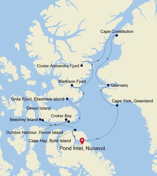
Pond Inlet, Nunavut to Pond Inlet, Nunavut Luxury Cruise itinerary:
show reverse itinerary
Day 2 Pond Inlet, Nunavut CANADA
Located in northern Baffin Island Pond Inlet is a small predo¬minantly Inuit community with a population of roughly 1 ,500 inhabitants. In 1818 the British explorer John Ross named a bay in the vicinity after the English astronomer John Pond. Today Pond Inlet is considered one of Canada's "jewels of the North" thanks to several picturesque glaciers and mountain ranges nearby. Many archaeological sites of ancient Dorset and Thule peoples can be found near Pond Inlet. The Inuit hunted caribou, ringed and harp seals, fish, polar bears, and walrus, as well as narwhals, geese, ptarmigans and Arctic hares long before European and American whalers came here to harvest bowhead whales. Pond Inlet is also known as a major center of Inuit art especially the printmaking and stone carving.
Day 3 Cape Hay, Bylot Island CANADA
Day 4 Beechey Island CANADA & Devon Island (Radstock Bay) CANADA
Beechey Island is a small island off the southwest coast of Devon Island, separated by a narrow waterway called the Barrow Strait. Captain William Edward Parry was the first European to visit the island in 1819. His lieutenant, Frederick William Beechey, named the island after his father, the artist William Beechey (1753–1839). Beechey Island played a significant role in the history of Arctic Exploration. During the winter of 1845-46, Sir John Franklin and his men camped on the island as part of their ill-fated quest to find the Northwest Passage. Mummified remains of three of Franklin’s crew were discovered, giving a better understanding of what happened before the disappearance of the expedition. In 1850 Edward Belcher used the island as a base while surveying the area. Later, in 1903, Norwegian explorer Roald Amundsen stopped at the island at the beginning of his successful voyage in search for the Northwest Passage. Subsequently, Beechey Island has been declared a "Territorial Historic Site" by the Northwest Territories government in 1975 and a National Historic Site of Canada in 1993. It now is part of Nunavut.
Devon Island is Canada’s sixth largest island and was first seen by Europeans in the early 17th century. The Thule culture had already settled there many centuries before, and left behind qarmat homes, made of rocks, whale bones, rock and sod walls, and skins for roofs that tell a story of over 800 years of human habitation. Other striking finds in this area are the many fossils of corals, crinoids and nautiloids that can be seen. Just across Lancaster Sound is Prince Leopold Island, a Canadian Important Bird Area, a federally listed migratory bird sanctuary, and a Key Migratory Bird Terrestrial Habitat site with large numbers of Thick-billed Murres, Northern Fulmars and Black-legged Kittiwakes that breed there.
Day 5 Croker Bay, Nunavut CANADA & Dundas Harbour, Devon Island CANADA
Austere, remote and a rather severe, Devon Island is as close the closest thing to Mars on planet Earth. The rocky terrain, dry, cold climate and 14-mile wide crater on the north of the island have made it home for a team of research scientists from NASA, who live in the small research station during the Arctic summer. Other than these few men and women, Devon Island is completely unpeopled, and the largest uninhabited island in the world. There was human habitation as recently as 1951, when a Canadian Mounted Police post that had been on the island since 1924 to monitor illegal activities such as whaling closed. At 320 miles long and 80–100 miles wide, it is the largest of the Parry Islands. Dundas Harbour is found in the south of the island. Then island is set in the icy Arctic Ocean, south of Ellesmere Island and west of Baffin Bay. This make it Canada’s sixth largest island. Discovered by English explorer William Baffin in 1616, the island did not make it on to any maps until William Edward Parry’s exploration of the Arctic in 1820. Despite the desolate conditions, the island does show signs of having sustained human life as many as 3,000 years ago, with the remains of a Thule settlement dating back to 1000 A.D., including tent rings, middens and a gravesite providing testament to the fact. The island is named Talluruti in local Inuktitut language, literally translating as “a woman’s chin with tattoos on it”, as from a distance the deep crevasses resemble traditional facial tattoos.
Day 6 Grise Fjord, Ellesmere island CANADA
Day 7 Markison Fjord CANADA
Markison Fjord was cut into Ellesmere Island by glaciers during the last Ice Age. Today, the combination of calm blue-green waters, icebergs, snow-covered mountains, and glaciers makes for a stunning scenic cruise. Polar bears and beluga are frequently seen in this area.
Day 8 Cruise Alexandra Fjord CANADA
Alexandra Fjord is a naturally formed inlet on the Johan Peninsula of Ellesmere Island. Although no permanent residents live here, it has been used periodically for a variety of purposes over the years. The Royal Canadian Mounted Police had a station here for ten years, from 1953 to 1963, during the beginning of the Cold War. At the time, it was the northern-most police station in the world. Later, between 1987 and 1992, this location was used as a seasonal research base.
Day 9 Cape Constitution GREENLAND
Day 10 Qaanaaq (Thule) GREENLAND
In AD 850, the Vikings established their parliament in Tórshavn, a name which translates as "Thor's harbor." It was named after Thor, the god of thunder and lightning in Norse mythology. The town became a center of trade for the island, and in fact was designated as the only legal place for the islanders to sell and buy products. This trade monopoly was abolished in 1856. Today it is the capital and largest city of the Faroe Islands, with fish-processing plants, a shipyard, and woolen products making up. It is considered to be one of the oldest capitals in Northern Europe.
Day 11 Cape York, Greenland GREENLAND
Visit the arctic seascape of Cape York, Greenland. Located on the northwestern coast of Greenland in Baffin Bay, Cape York is an important geographical feature delimiting the Melville Bay at its northwestern end and Kiatassuaq Island at its other end. There is a chain of coastal islands that stretches between the two capes, most notably Meteorite Island, named for the discovery one of the world’s largest iron meteorites in Savissivik, a settlement on the island. The iron from this meteorite attracted Inuit migrating from Arctic Canada who used the metal in making tools and harpoons. Visitors to this region will see iconic drifting blue-white icebergs that are shrinking as the earth temperature rises.
Day 12 Pond Inlet, Nunavut CANADA
Located in northern Baffin Island Pond Inlet is a small predo¬minantly Inuit community with a population of roughly 1 ,500 inhabitants. In 1818 the British explorer John Ross named a bay in the vicinity after the English astronomer John Pond. Today Pond Inlet is considered one of Canada's "jewels of the North" thanks to several picturesque glaciers and mountain ranges nearby. Many archaeological sites of ancient Dorset and Thule peoples can be found near Pond Inlet. The Inuit hunted caribou, ringed and harp seals, fish, polar bears, and walrus, as well as narwhals, geese, ptarmigans and Arctic hares long before European and American whalers came here to harvest bowhead whales. Pond Inlet is also known as a major center of Inuit art especially the printmaking and stone carving.
Please Note:
The excursions are provided as a sample of what may be offered on this voyage and are subject to change.
Pond Inlet, Nunavut to Pond Inlet, Nunavut Luxury Cruise reverse itinerary:
show main itinerary
Please Note: *
The excursions are provided as a sample of what may be offered on this voyage and are subject to change.
Day 12 Pond Inlet, Nunavut CANADA *
Located in northern Baffin Island Pond Inlet is a small predo¬minantly Inuit community with a population of roughly 1 ,500 inhabitants. In 1818 the British explorer John Ross named a bay in the vicinity after the English astronomer John Pond. Today Pond Inlet is considered one of Canada's "jewels of the North" thanks to several picturesque glaciers and mountain ranges nearby. Many archaeological sites of ancient Dorset and Thule peoples can be found near Pond Inlet. The Inuit hunted caribou, ringed and harp seals, fish, polar bears, and walrus, as well as narwhals, geese, ptarmigans and Arctic hares long before European and American whalers came here to harvest bowhead whales. Pond Inlet is also known as a major center of Inuit art especially the printmaking and stone carving.
Day 11 Cape York, Greenland GREENLAND *
Visit the arctic seascape of Cape York, Greenland. Located on the northwestern coast of Greenland in Baffin Bay, Cape York is an important geographical feature delimiting the Melville Bay at its northwestern end and Kiatassuaq Island at its other end. There is a chain of coastal islands that stretches between the two capes, most notably Meteorite Island, named for the discovery one of the world’s largest iron meteorites in Savissivik, a settlement on the island. The iron from this meteorite attracted Inuit migrating from Arctic Canada who used the metal in making tools and harpoons. Visitors to this region will see iconic drifting blue-white icebergs that are shrinking as the earth temperature rises.
Day 10 Qaanaaq (Thule) GREENLAND *
In AD 850, the Vikings established their parliament in Tórshavn, a name which translates as "Thor's harbor." It was named after Thor, the god of thunder and lightning in Norse mythology. The town became a center of trade for the island, and in fact was designated as the only legal place for the islanders to sell and buy products. This trade monopoly was abolished in 1856. Today it is the capital and largest city of the Faroe Islands, with fish-processing plants, a shipyard, and woolen products making up. It is considered to be one of the oldest capitals in Northern Europe.
Day 9 Cape Constitution GREENLAND *
Day 8 Cruise Alexandra Fjord CANADA *
Alexandra Fjord is a naturally formed inlet on the Johan Peninsula of Ellesmere Island. Although no permanent residents live here, it has been used periodically for a variety of purposes over the years. The Royal Canadian Mounted Police had a station here for ten years, from 1953 to 1963, during the beginning of the Cold War. At the time, it was the northern-most police station in the world. Later, between 1987 and 1992, this location was used as a seasonal research base.
Day 7 Markison Fjord CANADA *
Markison Fjord was cut into Ellesmere Island by glaciers during the last Ice Age. Today, the combination of calm blue-green waters, icebergs, snow-covered mountains, and glaciers makes for a stunning scenic cruise. Polar bears and beluga are frequently seen in this area.
Day 6 Grise Fjord, Ellesmere island CANADA *
Day 5 Croker Bay, Nunavut CANADA & Dundas Harbour, Devon Island CANADA *
Austere, remote and a rather severe, Devon Island is as close the closest thing to Mars on planet Earth. The rocky terrain, dry, cold climate and 14-mile wide crater on the north of the island have made it home for a team of research scientists from NASA, who live in the small research station during the Arctic summer. Other than these few men and women, Devon Island is completely unpeopled, and the largest uninhabited island in the world. There was human habitation as recently as 1951, when a Canadian Mounted Police post that had been on the island since 1924 to monitor illegal activities such as whaling closed. At 320 miles long and 80–100 miles wide, it is the largest of the Parry Islands. Dundas Harbour is found in the south of the island. Then island is set in the icy Arctic Ocean, south of Ellesmere Island and west of Baffin Bay. This make it Canada’s sixth largest island. Discovered by English explorer William Baffin in 1616, the island did not make it on to any maps until William Edward Parry’s exploration of the Arctic in 1820. Despite the desolate conditions, the island does show signs of having sustained human life as many as 3,000 years ago, with the remains of a Thule settlement dating back to 1000 A.D., including tent rings, middens and a gravesite providing testament to the fact. The island is named Talluruti in local Inuktitut language, literally translating as “a woman’s chin with tattoos on it”, as from a distance the deep crevasses resemble traditional facial tattoos.
Day 4 Beechey Island CANADA & Devon Island (Radstock Bay) CANADA *
Beechey Island is a small island off the southwest coast of Devon Island, separated by a narrow waterway called the Barrow Strait. Captain William Edward Parry was the first European to visit the island in 1819. His lieutenant, Frederick William Beechey, named the island after his father, the artist William Beechey (1753–1839). Beechey Island played a significant role in the history of Arctic Exploration. During the winter of 1845-46, Sir John Franklin and his men camped on the island as part of their ill-fated quest to find the Northwest Passage. Mummified remains of three of Franklin’s crew were discovered, giving a better understanding of what happened before the disappearance of the expedition. In 1850 Edward Belcher used the island as a base while surveying the area. Later, in 1903, Norwegian explorer Roald Amundsen stopped at the island at the beginning of his successful voyage in search for the Northwest Passage. Subsequently, Beechey Island has been declared a "Territorial Historic Site" by the Northwest Territories government in 1975 and a National Historic Site of Canada in 1993. It now is part of Nunavut.
Devon Island is Canada’s sixth largest island and was first seen by Europeans in the early 17th century. The Thule culture had already settled there many centuries before, and left behind qarmat homes, made of rocks, whale bones, rock and sod walls, and skins for roofs that tell a story of over 800 years of human habitation. Other striking finds in this area are the many fossils of corals, crinoids and nautiloids that can be seen. Just across Lancaster Sound is Prince Leopold Island, a Canadian Important Bird Area, a federally listed migratory bird sanctuary, and a Key Migratory Bird Terrestrial Habitat site with large numbers of Thick-billed Murres, Northern Fulmars and Black-legged Kittiwakes that breed there.
Day 3 Cape Hay, Bylot Island CANADA *
Day 2 Pond Inlet, Nunavut CANADA *
Located in northern Baffin Island Pond Inlet is a small predo¬minantly Inuit community with a population of roughly 1 ,500 inhabitants. In 1818 the British explorer John Ross named a bay in the vicinity after the English astronomer John Pond. Today Pond Inlet is considered one of Canada's "jewels of the North" thanks to several picturesque glaciers and mountain ranges nearby. Many archaeological sites of ancient Dorset and Thule peoples can be found near Pond Inlet. The Inuit hunted caribou, ringed and harp seals, fish, polar bears, and walrus, as well as narwhals, geese, ptarmigans and Arctic hares long before European and American whalers came here to harvest bowhead whales. Pond Inlet is also known as a major center of Inuit art especially the printmaking and stone carving.
* = Indicative
